
Mainnavigation
Subnavigation
BORDER
Pagecontent
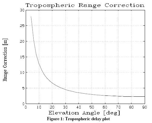
Tropospheric Delay Analysis for a GPS Satellite System
The plot below shows a tropospheric delay plot for a GPS satellite system. The script for generating this analysis is shown below.
function [] = demoGPS_TropoDelay ()
    %
    %     This demo computes the GPS tropospheric delay as a function
    %     of elevation angle.
    %
    %     p  = 1000 mbar
    %     T  = 290 K
    %     RH = .1
    %

    p  = 1000;  %  mbar
    T  =  290;  %  deg K
    RH =   .1;
    i  =    1;
    Ev = 4:2:90;

    for e = 4:2:90,
        dr(i) = TroposphericCorrection(p, T, RH, e*d2r);
        i = i+1;
    endfor

    erase,window('111')
    title('Tropospheric Range Correction');
    plot(Ev,dr,'grid')
    xlabel('Elevation Angle [deg]');
    ylabel('Range Correction [m]')
    demos

%endfunction